|
|
|
|
|||||||
|
|
|||||||||
|
|
|||||||||
|
|
|||||||||
|
Kettering can trace its name origins back to an early Romano-British settlement to the north of the present town an Anglo-Saxon settlement possibly to the east of the medieval village. It is in the mid-tenth century that we have our first historical reference to Kettering in a charter of 956 AD in which King Edwy granted ten "cassati" of land to his then Aelfsige the Goldsmith. The boundaries delineated in this charter would have been recognisable to most inhabitants of Kettering for the last thousand years and indeed can still be walked today. It is possible that Aelfsige the Goldsmith gave Kettering to the monastery of Peterborough as King Edgar in a charter dated 972 confirmed it to that monastery. Certainly at the time of the Domesday survey in 1086, Kettering manor is listed as a property held by the Abbey of Peterborough.
The prefix in this name, however, is more difficult to translate. Some say it comes from a tribal leader's name � Cuthfrith or Cutfrith � but other possibilities have been suggested. One is that it is from cetel, the Saxon word for a 'narrow valley'; another is that it derives from cyta, the Saxon for a kite. Kites were common birds of prey in early medieval times. In the Domesday Book (1086) the spelling was Cateringe and in 1557 Ketteryng.
The town grew mostly during the 19th century with the expansion of the boot and shoe industry and the coming of the railway line. Many of the street names reflect the history of this growth and the various people who have put Kettering on the map. In medieval times this area was covered by forests and farmlands, cottages and farms. The village of Kettering came under the jurisdiction of the Huxloe Hundred, which also incorporated places as far apart as Barnwell, Barton Seagrave, Islip and Lowick. The central meeting place was near Drayton, in a field still called Huxlow, a name incidentally deriving from Hoc's hlaw (barrow or hill). Kettering's Huxloe Place, off the High Street, recalls this old Hundred.
To the north of
here is Northall Street. This was Northolde in 1577, being a corruption
of north-wold. Wold was Saxon for 'weald' or 'woodland'. The trees growing
in this area separated the enclosed fields surrounding Kettering village
from the more open fields and common pastures beyond the parish boundaries.
Another name that recalls medieval farming is now the much sought after residential area of the Headlands. This comes from the old word for that of a field left unploughed. At the end of each strip and furlong the horse-ploughs would turn round, leaving behind heaps or heads, running at right angles to the furrows. Further away is Links Lodge. This name probably derives from the Saxon word hlinc meaning a 'bank', 'slope' or 'ridge'. It was most often used to indicate an embankment between two arable strips or furrows.
One area not owned by the Rockingham and Buccleuch estates was north of Northall. This was owned by John Robinson, the philanthropist who worked so hard to improve the conditions of the poor. His farmhouse stood on the south side of Northall and his farmland, totalling 110 acres, lay on the north side. The area was built over in the mid 19th century, such roads as Upper Field Street and Field Street Avenue now recalling the old landscape.
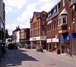
Sadly many old street names have disappeared. Market Street was once called Parkstile Lane and Walker Lane was Pudding Bag Lane because it was a cul-de-sac. At the bottom of Gold Street was Bakehouse Hill, named after an old bakery. Gold Street itself was Paul Street in the 18th century after two surgeons, father and son, Hugh and Matthew Paul. Meadow Road has been called Mill Lane and Gas Street, but before the 19th century was known as Goose Pasture Lane. Geese once fed here prior to being sold at market. Lower Street and its continuation into Rothwell Road was once Staunch Lane. This recalls the days when Kettering was famous for supplying the medical profession with stones which when ground into a powder helped to stop bleeding.
Victorian Kettering was the centre of the 19th century religious non-conformity and the missionary movement, and this has been preserved in many of the names. William Carey was the first of the great and good men associated with the town. He was born in 1761 at Paulerspury and spent much of his young life in Kettering before leaving for India as a missionary in 1793. The Carey Mission House and Carey Street was named after him. Andrew Fuller helped Carey found the Baptist Missionary Society and he is remembered in the Fuller Church and Fuller Street. In 1803 William Knibb was born in Market Street and he grew up to continue the missionary work of Carey; he is commemorated by the Knibb Centre and Knibb Street. The Toller Chapel and Toller Place are named after two ministers, father and son, who preached in Kettering for a total of 100 years. The chapel was built in 1723 for those independents who since 1662 had been worshipping in secret.
Dryland Street was once called Workhouse Lane owing to the location of the old poorhouse there. The road was renamed at the beginning of the 20th century soon after the sudden death of John Winter Dryland. The Dryland Memorial was erected in Sheep Street in 1906. J.W. Dryland settled in Kettering in 1857, setting up his doctor's practice at the corner of High Street and what was then Workhouse Lane. Soon he became a much loved and respected pillar of the local establishment. He was adviser to the workhouse (later the Poor Law Institute), medical officer to the council and chief medical adviser to the Midland Railway, the post office and fire brigade. It was largely due to his efforts that the Isolation Hospital was built in 1897. This became Rockingham Road Hospital, a site now occupied by the Paddocks housing estate. Dr. Dryland's son, Leslie Winter Dryland, continued his father's good work, continuing the doctor's practice until 1942. Kettering - From the Encyclopedia Britannica... Kettering and it's borough is an administrative and historic centre within the county of Northamptonshire, England. From the 17th century Kettering was a centre for the production of woolen cloth, and later of silk and plush. Since the Industrial Revolution, however, the town has been associated, like all its Northamptonshire neighbours, with leatherworking and the footwear industry. As the latter declined, Kettering sought more modern industries, competing since 1950 against Corby, a designated new town only 8 miles (13 km) away, for which Kettering serves as the railhead. Kettering has remained a prosperous town, with good road as well as rail connections. The borough also includes the towns of Desborough and Rothwell and a mainly rural area stretching north to the border of Leicestershire. Area borough, 90 square miles (234 square km). Pop. (1991) town, 47,186; (1998 est.) district, 82,400.
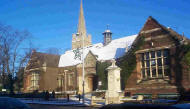
For further information regarding Kettering's historical heritage and architecture - please log onto the Kettering Civic Society web site: http://www.ketteringcivicsociety.ukf.net. The Church Drawings - Edward Bradley (1802 - 1883) These drawings of the Kettering Church and it's churchyard were made by Edward Bradley, a talented pupil of Thomas Carley, schoolmaster and parish clerk of Grafton Underwood. Carley was born without hands and the stumps of his arms extended only to the elbows. Yet with the aid of leather appliances he could wield knife and fork, write a beautiful hand and perform with facility most of the functions which seemed to require two hands for efficient performance. "Old Stumpy" as Bradley knew him, was a stern disciplinarian - if two boys were talking instead of working he would go behind them and with his stumps knock their heads together, very roughly.
Permission to reproduce this text has been kindly granted by Countryside Books, and is from the book entitled 'Northamptonshire Place-Names' by Charles Whynne-Hammond. This book is available through good bookshops and local libraries. Permission to reproduce these photographs has been kindly granted by Graham Beeby, Kettering. |
|

|
 Around
82,000 people live in the Borough of Kettering, which covers about 58,000
acres. The Borough comprises the towns of Burton Latimer, Desborough,
Kettering and Rothwell and the parishes of Ashley, Brampton Ash, Braybrooke,
Broughton, Cranford, Cransley, Dingley, Geddington, Grafton Underwood,
Harrington, Loddington, Newton and Little Oakley, Orton, Pytchley, Rushton,
Stoke Albany, Sutton Basset, Thorpe Malsor, Warkton, Weekly, Weston-by
Welland and Wilbarston.
Around
82,000 people live in the Borough of Kettering, which covers about 58,000
acres. The Borough comprises the towns of Burton Latimer, Desborough,
Kettering and Rothwell and the parishes of Ashley, Brampton Ash, Braybrooke,
Broughton, Cranford, Cransley, Dingley, Geddington, Grafton Underwood,
Harrington, Loddington, Newton and Little Oakley, Orton, Pytchley, Rushton,
Stoke Albany, Sutton Basset, Thorpe Malsor, Warkton, Weekly, Weston-by
Welland and Wilbarston.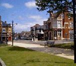 Words
and names ending with 'ing' usually derive from the early Saxon word
inga or ingas meaning 'the people of the' or 'tribe'. Ketter'ing' is
no exception as we can see this root in literary spellings used in the
10th century � Cytringan, Kyteringas and Keteiringan.
Words
and names ending with 'ing' usually derive from the early Saxon word
inga or ingas meaning 'the people of the' or 'tribe'. Ketter'ing' is
no exception as we can see this root in literary spellings used in the
10th century � Cytringan, Kyteringas and Keteiringan. 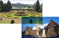 Wicksteed
Park, on the southern edge of Kettering, was given to the town by Charles
Wicksteed. He became a wealthy Victorian industrialist, having designed
and manufactured a revolutionary steam plough. Much of his wealth he
donated to good causes. Here his ambition was to create a pleasure park
for the enjoyment of Kettering residents and especially for their children.
Wicksteed
Park, on the southern edge of Kettering, was given to the town by Charles
Wicksteed. He became a wealthy Victorian industrialist, having designed
and manufactured a revolutionary steam plough. Much of his wealth he
donated to good causes. Here his ambition was to create a pleasure park
for the enjoyment of Kettering residents and especially for their children.
 On
the other side of the High Street is Wadcroft. In Saxon times this was
probably the croft (enclosed land or smallholding) where wad (woad)
was grown. This was a plant used in the making of dyes, especially those
requiring a blue colouring.
On
the other side of the High Street is Wadcroft. In Saxon times this was
probably the croft (enclosed land or smallholding) where wad (woad)
was grown. This was a plant used in the making of dyes, especially those
requiring a blue colouring. 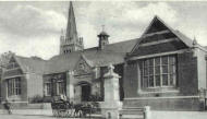
 Much
of the land on which Kettering has been built formed part of two manorial
estates, those belonging to the Rockingham family and the Dukes of Buccleuch
(who own nearby Boughton House). Not surprisingly therefore, many of
the modern street names reflect these aristocratic connections: Rockingham
Road, Duke Street, Buccleuch Street, Dalkeith Place, Montagu Street
and so on, Dalkeith, incidentally, is the honorary title of the eldest
son of the Duke of Buccleuch, whose family name is Montagu.
Much
of the land on which Kettering has been built formed part of two manorial
estates, those belonging to the Rockingham family and the Dukes of Buccleuch
(who own nearby Boughton House). Not surprisingly therefore, many of
the modern street names reflect these aristocratic connections: Rockingham
Road, Duke Street, Buccleuch Street, Dalkeith Place, Montagu Street
and so on, Dalkeith, incidentally, is the honorary title of the eldest
son of the Duke of Buccleuch, whose family name is Montagu.  In
many towns in England, street names often recall the traders and craftsmen
who once lived and worked in their own distinct quarters or districts.
Kettering is typical of this. Gold Street, Silver Street, Tanners Lane
and Sheep Street are such examples and are self-explanatory. Horse Market,
once called Hog Leys because pigs were fed there, became a general site
for the buying and selling of animals. Belfry Lane, off Wadcroft, was
formerly Bell Foundry Lane and named after Thomas Eayre's Bell Foundary.
In
many towns in England, street names often recall the traders and craftsmen
who once lived and worked in their own distinct quarters or districts.
Kettering is typical of this. Gold Street, Silver Street, Tanners Lane
and Sheep Street are such examples and are self-explanatory. Horse Market,
once called Hog Leys because pigs were fed there, became a general site
for the buying and selling of animals. Belfry Lane, off Wadcroft, was
formerly Bell Foundry Lane and named after Thomas Eayre's Bell Foundary.
 Streets
named after famous residents of the past are also common in Kettering.
Sir Alfred East, the 19th century artist whose name adorns the Art Gallery,
is also remembered in Alfred Street and his contemporary Thomas Cooper
Gotch, another artist, is recalled in Gotch Road and Gotch Close. Thomas's
brother, John Alfred Gotch, was the renowned architect responsible for
many of Kettering's famous buildings.
Streets
named after famous residents of the past are also common in Kettering.
Sir Alfred East, the 19th century artist whose name adorns the Art Gallery,
is also remembered in Alfred Street and his contemporary Thomas Cooper
Gotch, another artist, is recalled in Gotch Road and Gotch Close. Thomas's
brother, John Alfred Gotch, was the renowned architect responsible for
many of Kettering's famous buildings.  Sawyer's
Almshouses were named after another kindly man � Edmund Sawyer. he lived
in the 17th century and financed the building of these cottages to house
the poor and needy. Of later date is Lindsay Street, built in the second
half of the 19th century. At that time Canon Henry Lindsay was rector
(from 1861 to 1892) and he worked tirelessly for the sick. He also set
up the Church Institute.
Sawyer's
Almshouses were named after another kindly man � Edmund Sawyer. he lived
in the 17th century and financed the building of these cottages to house
the poor and needy. Of later date is Lindsay Street, built in the second
half of the 19th century. At that time Canon Henry Lindsay was rector
(from 1861 to 1892) and he worked tirelessly for the sick. He also set
up the Church Institute. 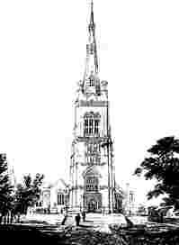 Kettering
- Historical Architecture
Kettering
- Historical Architecture 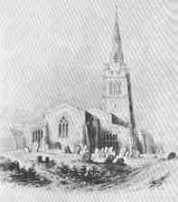 Bradley
was a favourite Victorian painter both of game and landscape which he
produced in great numbers, exhibiting 12 at the Royal Academy, 53 at
the British Institution, 77 at the Old Water-Colour Society and one
at the Royal Institute. A large number of his early topographical works
were collected by Thomas Dash and are to be found in the latter's collection
presented by his son to the British Museum.
Bradley
was a favourite Victorian painter both of game and landscape which he
produced in great numbers, exhibiting 12 at the Royal Academy, 53 at
the British Institution, 77 at the Old Water-Colour Society and one
at the Royal Institute. A large number of his early topographical works
were collected by Thomas Dash and are to be found in the latter's collection
presented by his son to the British Museum. kettering's web site - kettering history section: providing information relating to kettering history, kettering uk history, kettering northamptonshire, kettering northamptonshire history, kettering pictures, kettering photographs, kettering information, kettering research, kettering anglo saxon, kettering roman times, kettering church, northants churches, northamptonshire churches
Access to this web site is goverened by our Terms, Conditions, Privacy Policy & Disclaimer